Environment

Climate crisis laid bare as new map illustrates threat of rising sea levels

A new tool mapping sea level rises across the UK hopes to accelerate planning, and so help to avoid as much suffering as possible.

The map from Climate Central shows that, even by conservative estimates, large sections of the UK will be under sea level within 10 years. Image: Climate Central

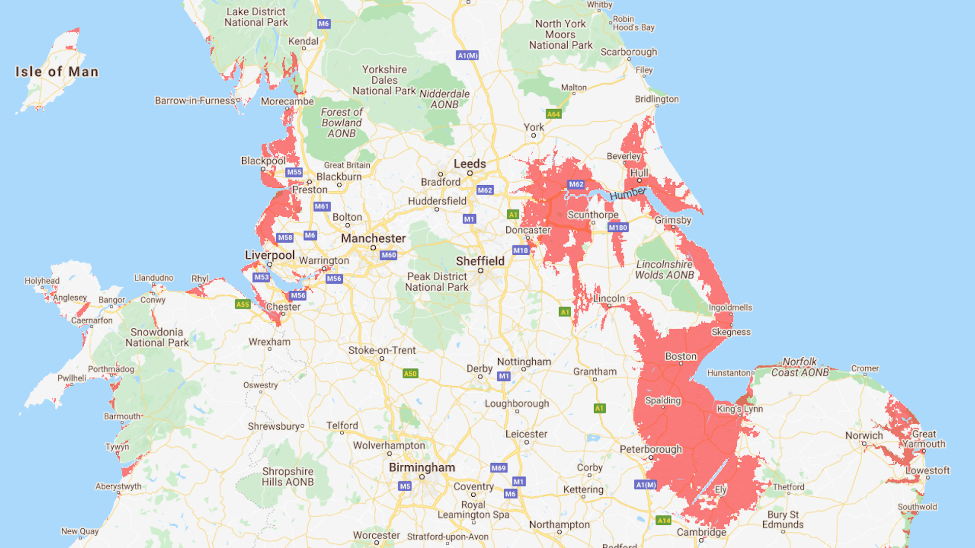
Scientists have warned for years about the impact of rising sea levels and now an interactive map can shows exactly where in the UK could be underwater as early as 2030.

The map, made by non-profit Climate Central, shows large parts of England’s east and north-east coast will be vulnerable to rising sea levels unless immediate action is taken to mitigate against global warming. London, Cardiff, Hull, Blackpool and Portsmouth are expected to be the most vulnerable to rising sea levels throughout the UK.

Dr Benjamin Strauss, chief executive of Climate Central, said the map improves upon previous data which tended to “overestimate land heights along the coast”.

Support The Big Issue and our vendors by signing up for a subscription.

“Our research found that its average error was roughly two metres worldwide, which means millions live closer to sea level and face greater coastal flood risk than earlier data suggested,” he said.

With more precise elevation data, the UK now has further information about which coastal towns will eventually need protection.

Image of map showing areas under water in projected map.
Rising sea levels
Map Credit: Climate Central

“Our greatest hope is that our tools accelerate planning for sea level rise, and so help to avoid as much suffering as possible,” Dr Strauss added.

Areas on the map that are shaded red are projected to be below the annual flood level come 2030.

Screenshot 2021-06-21 at 12.04.09
The north east of England is expected to be the worst affected area of the UK. Image: Climate Central

Large swathes of Lincolnshire, Norfolk and Cambridgeshire are predicted to be below sea level by 2030, including an area the size of London spanning nearly 70km in-land. Even by conservative estimates, the coastland running from Cambridge to Hull would need protection, including the Humber estuary.

Image of map showing areas under water in projected map.
Screen Shot 2021-06-18 at 16.31.09
Map Credit: Climate Central

Flooding along the River Thames and throughout central London could also drastically alter the landscape of the capital city.

The area surrounding Swansea’s coast has also made the climate change hit list, with land from Liverpool running up to Morecambe also set to be submersed.

Northern Ireland and Scotland are not under the same threat as England but some coastal towns remain vulnerable alongside areas of greater Glasgow.

Image of map showing areas under water in projected map.
Screen Shot 2021-06-18 at 16.32.06
Map Credit: Climate Central

Global leaders pledged to phase out coal-fired power generation at home alongside an agreement to end funding for new coal-burning power plants at the G7 Summit in Cornwall.

Later this year the UK will host the COP26 summit on climate change in Glasgow, with hopes of further galvanising the world’s efforts to tackle global warming.

COP26 President-Designate Alok Sharma is expected to say that this is the world’s “best chance” at limiting rising global temperatures to 1.5 degrees.

Full details of the study can be found on Climate Central’s website. 

Support your local Big Issue vendor

If you can’t get to your local vendor every week, subscribing directly to them online is the best way to support your vendor. Your chosen vendor will receive 50% of the profit from each copy and the rest is invested back into our work to create opportunities for people affected by poverty.
Vendor martin Hawes

Recommended for you

View all
What is the National Wealth Fund? Inside Labour’s less sexy, technocratic replacement for the £28bn
Rachel Reeves and Ed Miliband meeting the National Wealth Fund taskforce
Politics

What is the National Wealth Fund? Inside Labour’s less sexy, technocratic replacement for the £28bn

'It's a scandal': Outcry from Brits to nationalise water companies as bills set to rise – again
Water

'It's a scandal': Outcry from Brits to nationalise water companies as bills set to rise – again

Labour's plan for the climate and nature: The good, the bad and the glaringly absent
Keir Starmer and Angela Rayner announce new grey belt Labour housebuilding plan
General election 2024

Labour's plan for the climate and nature: The good, the bad and the glaringly absent

Water companies paid shareholders £377 for every hour they pumped sewage into seas, study finds
Pollution

Water companies paid shareholders £377 for every hour they pumped sewage into seas, study finds

Most Popular

Read All
Renters pay their landlords' buy-to-let mortgages, so they should get a share of the profits
Renters: A mortgage lender's window advertising buy-to-let products
1.

Renters pay their landlords' buy-to-let mortgages, so they should get a share of the profits

Exclusive: Disabled people are 'set up to fail' by the DWP in target-driven disability benefits system, whistleblowers reveal
Pound coins on a piece of paper with disability living allowancve
2.

Exclusive: Disabled people are 'set up to fail' by the DWP in target-driven disability benefits system, whistleblowers reveal

Cost of living payment 2024: Where to get help now the scheme is over
next dwp cost of living payment 2023
3.

Cost of living payment 2024: Where to get help now the scheme is over

Strike dates 2023: From train drivers to NHS doctors, here are the dates to know
4.

Strike dates 2023: From train drivers to NHS doctors, here are the dates to know